
Did you know the federal government is considering building a 6th interprovincial bridge near our community? Two of the proposed corridors will slice through the Eastern Greenbelt.
History
There are currently five interprovincial bridges between Ottawa and Gatineau. Discussions on building a 6th bridge have been going on for decades.
The National Capital Commission (NCC), Ontario Ministry of Transportation and Ministère des Transports du Québec launched an Environmental Assessment in 2006 to assess potential interprovincial crossing alternatives, with the goal to alleviate downtown congestion and deal with the large trucks that drive across downtown.
Timeline:
- In 2013 a study recommended a bridge across Kettle Island as the overall best option. The project was not approved.
- In 2020 the NCC commissioned a refresh of the 2013 study.
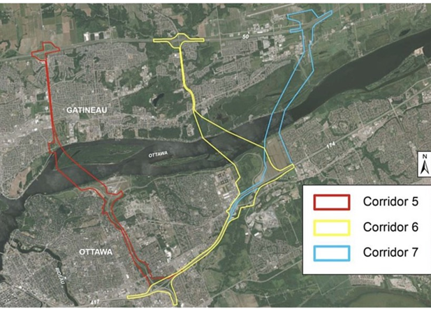
- In January 2022, the NCC reinitiated the project focussed on only three potential crossing corridors number 5, 6 and 7 East of downtown. See the map above.
- In October 2022, the NCC commissioned geotechnical studies of the Ottawa River to support those options.
What is happening – Fall 2022
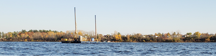
Public Services and Procurement Canada (PSPC) is presently doing geotechnical tests on the Ottawa River to inform decision-making on a 6th bridge across the Ottawa River, at a cost of almost $1 million. This is what the barge you see on the river is doing. They are testing to support three potential options called corridors. Corridor 5 would connect to the Aviation Parkway. Corridors 6 and 7 would connect to the 174 through a large part of the eastern portion of the Green Belt. Corridors 6 and 7 are very close to our community. Many have expressed concerns with the impact such a bridge would have on our community.
CGOWCA’s Interprovincial Crossing Committee
Our association has stood up an interprovincial crossing committee to study this renewed federal government project. Its mandate is:
- Working to better understand the issue of interprovincial transportation and a possible new interprovincial crossing near our community;
- Providing information to the community at large regarding the impacts of an interprovincial crossing in the east end; and
- Engaging with other stakeholders on this issue.
Primary concerns for Orléans
- Increased Traffic. The Sixth Provincial Crossing Refresh Summary indicates that as many as 25,870 vehicles a day[i] will be crossing the bridge on Corridor 6. That would have significant impact on the junction of the 417!
- Loss of the Eastern Greenbelt. The Green Belt is the narrowest in the East End. Both corridors 6 and 7 will require a significant area to accommodate access to the bridge[ii]. It will be a big loss of protected greenspace!
- Air Pollution. The prevailing winds are from the West. Emissions from the bridge will drift over Orléans and further East!
- Noise Pollution. Tens of thousands of vehicles a day will produce a constant background noise which will be amplified on humid or rainy days!
- Financial impact. After COVID-19, can we afford a multibillion-dollar bridge given the national, provincial and municipal debts and deficits exacerbated by growing interest rates to service all levels of government borrowing?
How to get involved
You may or may not be supportive of a new bridge that would cut through the Green Belt adjacent to our community. In either case you should voice your concerns with your political representatives:
- Laura Dudas, Ward 2 Orléans West-Innes – Laura.Dudas@ottawa.ca
- Ottawa Mayor, Mark Sutcliffe – Mark.Sutcliffe@ottawa.ca
- Provincial Representative, Stephen Blais – sblais.mpp.co@liberal.ola.org
- Federal Representative, Marie-France Lalonde – Marie-France.Lalonde@parl.gc.ca
You can also contact the committee with any questions or comments by writing to CGNbridgecommittee@gmail.com.
Relevant documents and additional information
Sixth Interprovincial Bridge Crossing Study Refresh – Summary Report (NCC)
It provides an overview of existing conditions within the study area, identifies baseline information and key changes that can potentially affect the 2013 findings, conclusions and recommendation, directions that will assist the City in the preparation of future planning for this area. In addition, this report highlights what further studies would be required should this project proceed to the next phase of a Federal Environmental Assessment.
Future Interprovincial Crossings in the National Capital Region Environmental Assessment Study (NCC)
This study should inform us of the impact on the environment of a new bridge on the east side of Ottawa. It covers the following elements:
Natural Environment: Species at Risk (SAR), air quality, fisheries and fish habitat, hydrotechnical, terrestrial, wetlands, environmentally significant and sensitive areas.
Cultural Environment: Heritage and archaeological resources, aboriginal interests.
Water Use and Resources: Water treatment facilities, wastewater treatment plants.
Social Environment: Human health (air quality, noise and vibration), community impacts, aesthetics and views; boating and float plane activities, scenic parkways, recreational facilities.
Land Use and Property: Official Plans, federal Master Plans, development, property requirements, museum, airports, hospital, residential, commercial, industrial, institutional, agricultural, contamination (soils sediment).
Economic Environment: Economic development.
Traffic and Transportation: Trucking, traffic operations, transit operations, traffic safety, connectivity to non-motorized infrastructure.
Costs: Construction of the crossing connection and appropriate mitigation measures, property, operations, maintenance.
Transportation Master Plan Update | Engage Ottawa
This plan provides the vision of the City on the matter of transportation.
TRANS Committee – A Joint Transportation Planning Committee Serving the National Capital Region (ncr-trans-rcn.ca)
The TRANS Committee was established in 1979 to co-ordinate efforts between the major transportation planning agencies of the National Capital Region. The Committee is a neutral forum for the exchange of information on technical guidelines and best practices. In addition, it manages transportation studies and collects data for transportation planning.
Downtown Ottawa (Truck) Tunnel Feasibility Study
This 2016 study is about the option of building a tunnel under the City from the Macdonald-Cartier bridge to a junction with the 417 highway. It is reported to have the least impact on the environment.
Minister of Public Services and Procurement Mandate Letter (pm.gc.ca)
The Prime Minister, in his mandate letter to the Minister, directed the Minister to “Continue to improve crossings in the National Capital Region, moving forward with Budget 2019 commitments to replace the Alexandra Bridge, addressing the demonstrated need for an additional National Capital Region crossing with the Long-Term Integrated Interprovincial Crossings Plan led by the National Capital Commission (NCC), and investing to rehabilitate and maintain existing crossings, including the Chaudière and Macdonald-Cartier bridges.
Truck Traffic Study (Link to come when published)
A truck traffic study is planned for fall 2022. This study will provide data essential to the creation of a sustainable transportation plan, and inform whether a 6th bridge is needed.
[i] Sixth-Interprovincial-Crossing-Refresh-Summary-Report-EN-April-8-2020.pdf (ncc-website-2.s3.amazonaws.com)
[ii] Microsoft Word – Phase 2B Study Design Report V23 _25 May 2010_ EN FINAL.doc (ncrcrossings.ca)